An Ancient Fishing Industry in Sandy Haven Pill
The mudflats, sand bars and rocks of the Milford Haven waterway have long been sites for shellfish gathering. Today native oysters, Pacific oysters, mussels, razor shells, cockles, limpets and carpet shell clams occur. The Romans in Britain like to eat oysters and sea urchins. The native oysters were gathered from the shore after storms. They could also be obtained by dredging. Owen in 1603 describes extensive beds of native oysters and an associated fishery in the Milford Haven Waterway. This is believed to have been mainly the work of Flemish people who migrated into south Pembrokeshire. In 1106 storms washed away the sand dunes protecting parts of coastal Flanders and caused widespread flooding of the low lying areas. Many Flemish people fled to seek new lands. Many arrived in London to petitioned King Henry 1st (second son of William the Conqueror and his wife) for empty land where they might settle. King Henry 1st did not like the Flemish refugees and was having problems with hostile Welshmen. So he solved two problems together by giving them land that did not belong to him in the remotest part of his Kingdom – west Wales. This was the land of Rhos (Roose) in Pembrokeshire. It is an area bounded by the Western Cleddau River in the east, by the Milford Haven Waterway in the south and St Brides Bay in the west. It included all of the Dale Peninsula. The industrious Flemish people arrived at Sandy Haven in their boats. One of their industries was collecting shellfish.
The shell fish industry lasted for centuries. Within living memory the people of the ancient village of Llangwm in the Rhos area gathered oysters, cockles, mussels, prawns, and caught herrings and salmon by using nets. During the Victorian era, Llangwm women were famous for walking with their baskets of oysters, cockles and prawns around Pembrokeshire and to the capital of Haverfordwest for sale. The women would dress in their colorful traditional Welsh clothing and carry heavy baskets of produce for long distances on foot.
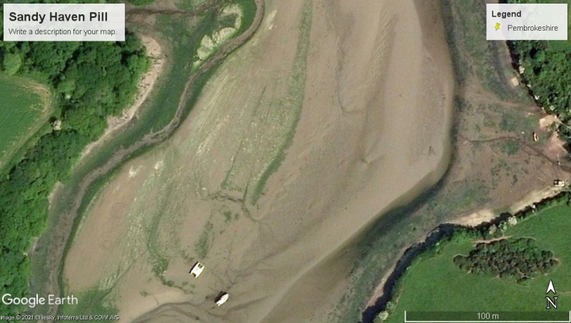
There is some evidence, but no memory today, of an ancient fishing industry in Sandy Haven Pill. This may date back to the time of the arrival of the Flemish people. The discovery was made using Google Earth Imagery, where in the middle of Sandy Haven pill on a long sandbank, two lines can be seen (see image). One end of the two lines is near a catamaran sitting on the sand bank. The lines only appear at certain times. They are only on the Google Earth images of December 2006. The lines are 73 m long and spaced 16m apart at one end and 6 m apart at the other.
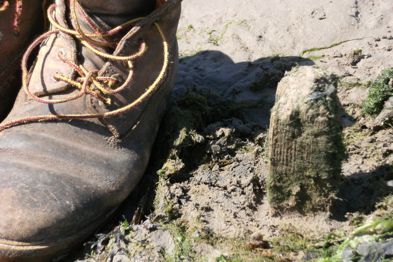
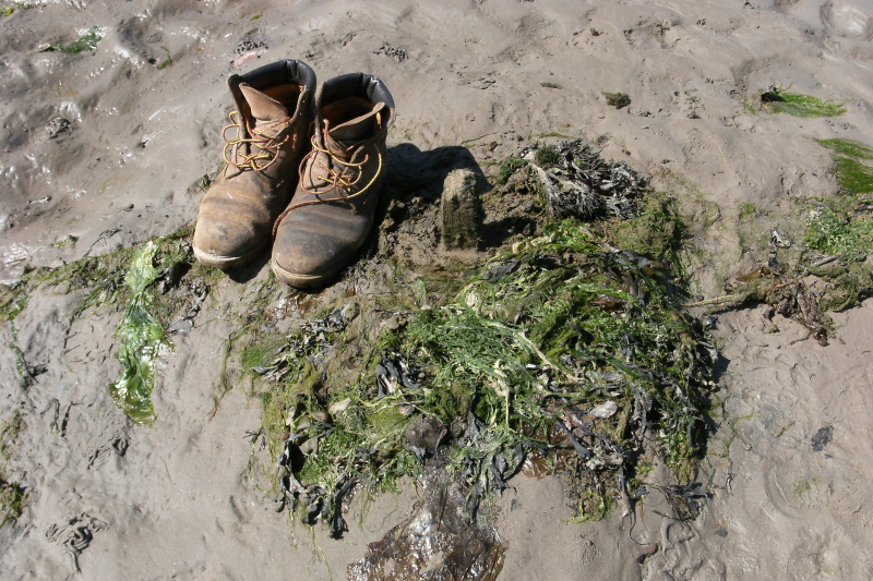
A field investigation shows them to be lines of spaced wooden stakes (see photographs). Each stake is square cut and about 2 inches on the side. They are visible only when the sand level has been lowered in winter, so that in summer seaweed grows attached to the remains of the wooden stakes. The length of the lines and their orientation along the tidal pill suggests two possibilities for an ancient industry. First they could be lines of posts for growing oysters or mussels. Similar lines of posts can be seen in many tidal inlets today of South Island New Zealand, where oysters are grown in plastic net bags attached to the wooden posts. The second possibility is that the lines of stakes were rigged with seine nets to form a fish trap that could be easily accessed at low tide. At present there is no known written record of fishing industry in Sandy Haven Pill, but it would be possible to date the wooden posts using either tree ring analysis or radiocarbon dating. On the other had if funding was available for a radiocarbon date, then it might be preferable to know the age of the tusk of a woolly mammoth dug up under Hakin Bridge and now on display in Milford Museum.